School nearby Rawash Industrial Secondary School Joint
Egypt
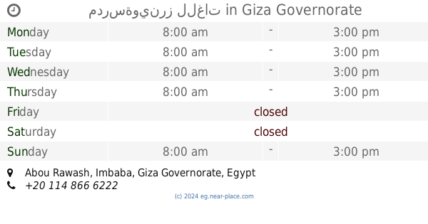
School nearby Rawash Industrial Secondary School Joint
Rawash Industrial Secondary School Joint
Abou Rawash, Imbaba Egypt
contacts phone
:
+20
Latitude:
30.0457438
, Longitude:
31.0884681
read more
nearest School
133 m
Al Iman School for Basic Education
Abou Rawash, Imbaba
School
read more
139 m
مدرسة ابورواش الثانوية العامة المشتركة
Abou Rawash, Imbaba
School
read more
224 m
School Rawash per semester
Abou Rawash, Imbaba
School
read more
758 m
مدرسة النورس الخاصة
Al Mansoureya Canal, Abou Rawash, Imbaba
School
read more
1.048 km
School martyr Jamal Mahmoud
Abou Rawash, Imbaba
School
read more
1.205 km
Genius Dome International School
School
read more
1.446 km
مدرسة وينرز للغات
Abou Rawash, Imbaba
School
read more
1.448 km
مدرسةوينرز للغات
Abou Rawash, Imbaba
School
read more
1.45 km
Winners Language school
20, Al Mansoureya Canal Road
School
read more
1.731 km
مدرسة الشهيد نقيب اسلام علي المكاوي
Kerdasah, Imbaba
School
read more
1.904 km
School Kerdasa w Speaking Npn
Al Omraneyah
School
read more
1.96 km
مدرسه كرداسه الرسميه للغات
Alexandria Desert Road
School
read more
2.031 km
Built junior high school scheduled
Kerdasah, Imbaba
School
read more
2.123 km
مدرسة حورس
طريق أبو رواش, Bani Magdoul, Imbaba
School
read more
2.59 km
Green Heaven Language School
School
read more
2.708 km
El Salam Primary Mixed School
Kerdasah, Imbaba
School
read more
2.756 km
Kerdasa primary
El-Souk El-Kadeem, Imbaba
School
read more
2.898 km
Pharaohs Language School - مدرسة فاروز للغات
Kafr Hakeem, Imbaba
School
read more
3.031 km
Smart City School
Kafr Hakim Road, Kafr Hakeem, Imbaba
School
read more
3.078 km
Middle East International School
Nahia, Imbaba
School
read more
3.098 km
مدرسة ميدل ايست
Nahia, Imbaba
School
read more
3.208 km
Mavericks International School
School
read more
3.222 km
Smart International School
Egipt
School
read more
3.602 km
El Tawhed El Islamya
Kerdasah, Imbaba
School
read more
3.639 km
BP School
الكيلو 26, Imbaba
School
read more
📑
all categories
Accounting
Administrative area level 1
Administrative area level 2
Airport
Amusement park
Aquarium
Art gallery
Atm
Bakery
Bank
Bar
Beauty salon
Bicycle store
Book store
Bowling alley
Bus station
Cafe
Campground
Car dealer
Car rental
Car repair
Car wash
Casino
Cemetery
Church
City hall
Clothing store
Colloquial area
Convenience store
Courthouse
Dentist
Department store
Doctor
Electrician
Electronics store
Embassy
Finance
Fire station
Florist
Food
Funeral home
Furniture store
Gas station
General contractor
Grocery or supermarket
Gym
Hair care
Hardware store
Health
Home goods store
Hospital
Insurance agency
Jewelry store
Laundry
Lawyer
Library
Light rail station
Liquor store
Local government office
Locality
Locksmith
Lodging
Meal delivery
Meal takeaway
Mosque
Movie rental
Movie theater
Moving company
Museum
Natural feature
Neighborhood
Night club
Painter
Park
Parking
Pet store
Pharmacy
Physiotherapist
Place of worship
Plumber
Point of interest
Police
Political
Post office
Premise
Real estate agency
Restaurant
Roofing contractor
Route
Rv park, camping
School
Shoe store
Shopping mall
Spa
Stadium
Storage
Store
Subway station
Supermarket
Synagogue
Taxi stand
Train station
Transit station
Travel agency
University
Veterinary care
Zoo
administrative area level 3
sublocality level 1
↑