places in Luxor
Egypt
Luxor
Luxor
Administrative Region:
Luxor Governorate
population:
506 588
calling code:
+20-95
postcode:
85831
85839
85841
85852
85861
85951-85952
85954-85956
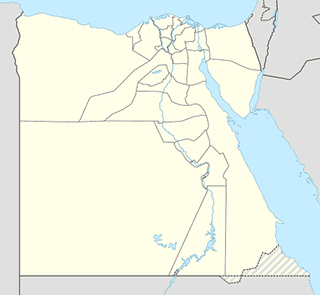
Location on the map of Egypt
Luxor
Art gallery
New Hamees Papyrus Gallery
Mabad Al Karnak, El-Karnak, Luxor
Art gallery
read more
Car repair
Mohamed Aly Atteya For Cars Spare Parts
امدينة، مدينة الأقصر، الأقصر
Car repair
read more
Mechanical campaign of the Directorate of Health Affairs in Luxor
Luxor International Hospital Street, Gazirat Al Awameyah, Luxor
Car repair
read more
Samir Hijazi for the importation and distribution of auto parts
شارع صلاح سالم, مدينة الأقصر, Luxor
Car repair
read more
ابناء محمد محمود المدامودي للإطارات والبطاريات
Luxor City, Luxor
Car repair
read more
مركز الدويكى لخدمه جميع انواع السيارات
Luxor
Car repair
read more
El Fares Auto Group
Al Hagagya, Luxor City, Luxor
Car repair
read more
Church
Church of the Archangel Michael
Luxor City, Luxor
Church
read more
Saint Anthony and St. Paul Church, Luxor
Al Kanisa, Luxor City, Luxor
Church
read more
Francescan Church for Latin
Mabad Al Karnak, Luxor City, Luxor
Church
read more
Ava Wanas Church
Luxor City, Luxor
Church
read more
The Michael Angel Church, Luxor
Al Saha, Luxor City, Luxor
Church
read more
Church of the Great Martyr St. George in Luxor
Al Sakakini, Luxor City, Luxor
Church
read more
كنيسة دير الشهيد العظيم الأمير تادرس بغرب الأقصر ايبارشية الأقصر و توابعها
Al Mahamed Bahri Al Okser, Qesm Al Wahat Al Khargah
Church
read more
Saint Mary Church, Luxor
Mabad Al Karnak, Luxor City, Luxor
Church
read more
Souls Salvation Society Luxor
Saman, Luxor City, Luxor
Church
read more
Evangelical Church Of Luxor
Mabad Al Karnak, Luxor City, Luxor
Church
read more
Locality
Model Village
Model Village
Locality
read more
Luxor
Luxor
Locality
read more
Al Aqaltah
Al Aqaltah
Locality
read more
Al Biirat
Al Biirat
Locality
read more
Night club
Mr. Lhalipo Touristic Restaurant
ش معبد الكرنك، الأقصر
Night club
read more
📑
Luxor all categories
Accounting
Administrative area level 1
Administrative area level 2
Airport
Amusement park
Art gallery
Atm
Bakery
Bank
Bar
Beauty salon
Book store
Cafe
Car dealer
Car rental
Car repair
Cemetery
Church
Clothing store
Courthouse
Dentist
Doctor
Electronics store
Finance
Fire station
Food
Furniture store
Gas station
Grocery or supermarket
Gym
Health
Home goods store
Hospital
Jewelry store
Laundry
Lawyer
Library
Local government office
Locality
Lodging
Meal takeaway
Mosque
Museum
Natural feature
Neighborhood
Night club
Park
Parking
Pharmacy
Physiotherapist
Place of worship
Point of interest
Police
Post office
Premise
Real estate agency
Restaurant
Route
Rv park, camping
School
Shopping mall
Spa
Stadium
Storage
Store
Supermarket
Travel agency
University
Veterinary care
administrative area level 3
↑