Cemetery nearby المقابر
Egypt
Cemetery nearby المقابر
المقابر
Unnamed Road, Mit Helfa, Qalyoub Egypt
contacts phone
:
+20
Latitude:
30.1670874
, Longitude:
31.2487241
read more
nearest Cemetery
1.093 km
مدافن عزبة السعادنة
Egypt
Cemetery
read more
1.093 km
مدافن عزبة السعادنة
Egipt
Cemetery
read more
1.093 km
مدافن عزبة السعادنة
Ägypten
Cemetery
read more
1.093 km
مدافن عزبة السعادنة
Egypten
Cemetery
read more
1.093 km
مدافن عزبة السعادنة
Egipto
Cemetery
read more
1.742 km
مدافن قليوب المحطة
Egipt
Cemetery
read more
1.742 km
مدافن قليوب المحطة
Ägypten
Cemetery
read more
1.742 km
مدافن قليوب المحطة
Egypten
Cemetery
read more
1.742 km
مدافن قليوب المحطة
Egypt
Cemetery
read more
1.742 km
مدافن قليوب المحطة
Egipto
Cemetery
read more
2.069 km
مقابر ميت حلفا
طريق المقابر، ميت حلفا، قليوب
Cemetery
read more
2.074 km
مقابر ميت حلفا
Egypten
Cemetery
read more
2.074 km
مقابر ميت حلفا
Egipt
Cemetery
read more
2.074 km
مقابر ميت حلفا
Egypt
Cemetery
read more
2.074 km
مقابر ميت حلفا
Egipto
Cemetery
read more
3.567 km
مقابر قليوب
Qalyoub
Cemetery
read more
4.481 km
Tombs Bahteem
Bahtim, Qesm Than Shubra Al Kheimah
Cemetery
read more
8.41 km
مدفن البخورى
Ägypten
Cemetery
read more
8.41 km
مدفن البخورى
Egypten
Cemetery
read more
9.952 km
مقابر المسلمين بكفر الشرفا
Egypt
Cemetery
read more
12.804 km
Cemetry Coptic Christian
Al Golf, Nasr City
Cemetery
read more
13.613 km
مدافن الجمعية الخيرية لابناء مشيرف منوفية بالقاهرة
Egipt
Cemetery
read more
13.613 km
مدافن الجمعية الخيرية لابناء مشيرف منوفية بالقاهرة
Egypt
Cemetery
read more
14.347 km
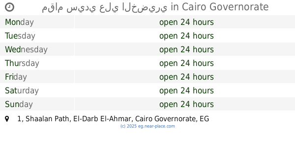
مقام سيدي علي الخضيري
1 Shaalan Path, El-Darb El-Ahmar
Cemetery
read more
14.811 km
ضريح الشيخ ابو الحسن المنوفي
Bab Al Wadaa, Al Abageyah, Qism El-Khalifa
Cemetery
read more
📑
all categories
Accounting
Administrative area level 1
Administrative area level 2
Airport
Amusement park
Aquarium
Art gallery
Atm
Bakery
Bank
Bar
Beauty salon
Bicycle store
Book store
Bowling alley
Bus station
Cafe
Campground
Car dealer
Car rental
Car repair
Car wash
Casino
Cemetery
Church
City hall
Clothing store
Colloquial area
Convenience store
Courthouse
Dentist
Department store
Doctor
Electrician
Electronics store
Embassy
Finance
Fire station
Florist
Food
Funeral home
Furniture store
Gas station
General contractor
Grocery or supermarket
Gym
Hair care
Hardware store
Health
Home goods store
Hospital
Insurance agency
Jewelry store
Laundry
Lawyer
Library
Light rail station
Liquor store
Local government office
Locality
Locksmith
Lodging
Meal delivery
Meal takeaway
Mosque
Movie rental
Movie theater
Moving company
Museum
Natural feature
Neighborhood
Night club
Painter
Park
Parking
Pet store
Pharmacy
Physiotherapist
Place of worship
Plumber
Point of interest
Police
Political
Post office
Premise
Real estate agency
Restaurant
Roofing contractor
Route
Rv park, camping
School
Shoe store
Shopping mall
Spa
Stadium
Storage
Store
Subway station
Supermarket
Synagogue
Taxi stand
Train station
Transit station
Travel agency
University
Veterinary care
Zoo
administrative area level 3
sublocality level 1
↑