Bar nearby Space PS
Coronavirus disease (COVID-19) Situation
confirmed cases
516023
deaths
24613
Egypt
Bar nearby Space PS
Space PS
146, Al Haram, Al Omraneyah, Giza Governorate, EG Egypt
contacts phone
:
+20 102 477 9910
Latitude:
29.993916
, Longitude:
31.159577
larger map & directions
read more
nearest Bar
155 m
Africana Club
158 Al Haram, Oula Al Haram, Al Omraneyah
Bar
read more
354 m
酒屋ワンフそば
Abd El-Shafy, Oula Al Haram, Al Omraneyah
Bar
read more
1.364 km
مركز الملكة والامير
Atati, Al Haram
Bar
read more
1.438 km
El Andalous Casino
186 ش الهرم، أولى الهرم، الجيزة
Bar
read more
1.85 km
كافية الخان
Al Haram, Kafr Nassar, Al Haram
Bar
read more
2.747 km
Sultan Lounge
Mena House Oberoi Hotel, Pyramids Road, Haram, Cairo
Bar
read more
2.78 km
Mamlouk Bar
Mena House Oberoi Hotel, Pyramids Road, Haram, Cairo
Bar
read more
3.804 km
Triple Coffee&Juice
422 El-Malek Faysal Mosque
Bar
read more
4.803 km
بساطه كافيه
Al Omraneyah
Bar
read more
5.114 km
الدخاخني
Al Haram
Bar
read more
6.777 km
Tia Maria Pub and Restaurant
32 Jeddah, Ad Doqi
Bar
read more
6.889 km
Bonbon coffeebar
حدائق اﻷهرام, Al Haram
Bar
read more
7.232 km
Alkobesy Fresh Juices
Charles de Gaulle, Ad Doqi A, Ad Doqi
Bar
read more
7.594 km
Hamada Morsi
17 Mohammed Mahmoud Shaaban, Ad Doqi
Bar
read more
8.775 km
River Club Bar Association Maadi
Nile Corniche
Bar
read more
9.133 km
Cairo Jazz Club
197 26th of July Corridor, Madinet Al Eelam, Al Agouzah
Bar
read more
9.602 km
Deals
Muhammad Mazhar, AZ Zamalek
Bar
read more
9.697 km
B&w
23 Rihan Lane, El-Shaikh Abd Allah, Abdeen
Bar
read more
10.25 km
Drinkies
Bab Al Louq, Abdeen
Bar
read more
10.572 km
مقابر البساتين
Al Maqaber, Al Basatin Al Gharbeyah, Qism El-Khalifa
Bar
read more
10.638 km
Dream Transporter
Bar
read more
11.129 km
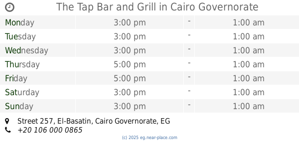
The Tap Bar and Grill
Street 257
Bar
read more
11.362 km
Ace Club
2, Victoria Sq., Al Maadi
Bar
read more
11.363 km
Beba roll
El-Tahrir City, Imbaba
Bar
read more
17.656 km
Zamzam
Monshaat Naser, Qesm Helwan
Bar
read more
📑
all categories
Accounting
Administrative area level 1
Administrative area level 2
Airport
Amusement park
Aquarium
Art gallery
Atm
Bakery
Bank
Bar
Beauty salon
Bicycle store
Book store
Bowling alley
Bus station
Cafe
Campground
Car dealer
Car rental
Car repair
Car wash
Casino
Cemetery
Church
City hall
Clothing store
Colloquial area
Convenience store
Courthouse
Dentist
Department store
Doctor
Electrician
Electronics store
Embassy
Finance
Fire station
Florist
Food
Funeral home
Furniture store
Gas station
General contractor
Grocery or supermarket
Gym
Hair care
Hardware store
Health
Home goods store
Hospital
Insurance agency
Jewelry store
Laundry
Lawyer
Library
Light rail station
Liquor store
Local government office
Locality
Locksmith
Lodging
Meal delivery
Meal takeaway
Mosque
Movie rental
Movie theater
Moving company
Museum
Natural feature
Neighborhood
Night club
Painter
Park
Parking
Pet store
Pharmacy
Physiotherapist
Place of worship
Plumber
Point of interest
Police
Political
Post office
Premise
Real estate agency
Restaurant
Roofing contractor
Route
Rv park, camping
School
Shoe store
Shopping mall
Spa
Stadium
Storage
Store
Subway station
Supermarket
Synagogue
Taxi stand
Train station
Transit station
Travel agency
University
Veterinary care
Zoo
administrative area level 3
sublocality level 1
↑